|
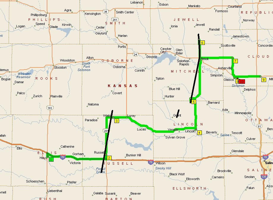
Anticipating an early show, I left KC at 730am with an initial target of Lyons KS. Checked 12Z obs/model data along I-70, and adjusted my target northwestward to Hoisington. Made it there by noon. The strength of the dry slot advertised by the NAM and GFS was certainly panning out. Eventually I wandered up to the Russell county line, where pesky stratocu were more minimal. A deepening cyclonic arc of convection was already underway in far NW KS, on the northern periphery of the ejecting mid-level low. |
 |
A NNW-moving storm developed on the tail of the convective arc, about 30 miles to my west. I opted to check this one out and jogged up to I-70. It looked fairly vigorous as I approached it near Hays, but was soon tackled by more messy cells from the south. Its FF core pelted me with some half inch hailstones, though, which was a good sign. Here is an image of the Hays storm taken at 108pm. |
 |
Equipment problems from hell (a pattern lately) ensued thereafter. I was able to grab an ICT radar image courtesy of WIFI, and headed east to intercept additional development as it spiraled northward across I-70; one cell in particular looked to have its eyes set on Russell. When I reached town, I parked just north of I-70 and noticed something impressive coming out of the rain (145pm). |
 |
Moved north a shade and started video for the day at that time... my first recorded words being, "I'm a little bit shocked." |
 |
Another shot of this stout updraft. |
 |
The mini-supercell now sported a mini-wall cloud. I figured I'd have enough time to get north of town where I would have a clear view of things, and thus started to head north on Highway 281 at 151pm. The Russell tornado touched down literally seconds after I turned my back on the storm. |
 |
Through trees and buildings, I soon noticed some definite funny business beneath the updraft, and then verified the full-fledged tornado. I snapped this over-the-shoulder still (154pm) while looking for a good place to pull over. |
 |
Finally, I found a relatively clear vantage point on the northwest side of town to watch the tornado. (156pm) |
 |
A telephone pole and a raindrop both vie for camera time. |
 |
Tornado hit some sort of manufacturing building about this time, ripping pieces of the roof off into the air. |
 |
|
 |
|
 |
Dissipating tornado, and parent mesocyclone with RFD cleft! Amazing. (159pm) |
 |
The storm passes right up Highway 281. |
 |
Fully HP, the supercell engulfed the town of Waldo ~230pm (as in photo). I abandoned the storm at that time. With no nowcasting available, I instinctively headed east on Highway 18 to look for new cells. A tornado warning was issued for a nice-looking storm to my northeast near Sylvan Grove. I tried to catch up with it north of Lincoln, but was sideswiped by a new storm(s) farther south. |
 |
The southern storm became visible as I neared the Mitchell county line on Highway 14 (325pm). I was still very confused as to what I was looking at; I thought this was the northern storm, due to some confusing reports in the tornado warning text. |
 |
From radio reports, it was becoming clear the northern storm was producing a long-track tornado. [As it turned out, the storm was just far enough ahead of me that haze and/or visibility restrictions caused by the southern storm's FF core made it impossible to see, even though it was tracking only 10 miles to my northwest.] Still not understanding the situation, I became frustrated as I continued to pursue the southern storm along Highway 14 (shown in this photo, 335pm, looking southwest). It was highly elongated, with no visible rotation or condensing inflow at cloud base. |
 |
From the latest warning, it seemed I could beat the northern storm's tornadic updraft to the Jewell county line. When I got north of Beloit, a new tornado warning was issued for northeastern Mitchell county-- for the southern storm! I finally let the confirmed-tornadic storm go and prepared to intercept/closely observe the southern storm, whose increasingly rounded updraft was just to my south (photo, 358pm). |
 |
I moved back to the intersection of Highway 14 and Highway 24 in northwest Beloit for a closer look (photo, 401pm). An SWS on the tor warning came over the radio, indicating a tornado was spotted near Beloit. However, the more I looked around, the less clear it was to me where the area of "interest" really was. I climbed back into the vehicle and began moving back north. Then I noticed that rain was being driven ferociously against my car, and only on the right-hand side. This was indicative of strong easterly inflow winds into the updraft base overhead. |
 |
The tornado revealed itself to me at 406pm as a broad, frenzied circulation racing erratically northward 20 yards to my right in a farm field. (A scary moment until it moved onward). The ground was soaked, thus dust/debris was minimal. The tornado then became more focused/organized into a cylinder... then began to decelerate and became very tough to see. Meanwhile, the mesocyclone finished passing overhead and became astonishingly clear. Here is the first photo I took of the mesocyclone as I followed it up Highway 14. The indistinct tornado is emanating from the particularly angry lowered portion of the meso, to the right of the highway.
|
 |
The updraft base darkened and lowered dramatically, as the transition to a broad multiple vortex tornado occurred. Due to the relatively small scale of the event (minisupercell with extremely low cloud base), photos suggest I was following a good distance behind the tornado. In actuality, I was only following 100-200 yards behind it. |
 |
Video turned out quite well. Photos, not so much. |
 |
Cropped photo showing ugly vortices dancing through trees. Rotation at cloud base was violent... but didn't seem to translate well to the surface. |
 |
On a few occasions, individual vortices came careening left to right around the near side of the tornadocyclone. I caught one of them in this photo... just above the wiper blade and to the left of the highway. |
 |
The tornado's appearance was impressive in that it was about four times wider than it was tall. But it wasn't a large tornado; it's just that the cloud base was literally right above the treetops... perhaps only 100 feet off the ground. |
 |
Between the LEO vehicle, trees, powerpoles, and haybales, as well as steady rain and the windshield wipers... this wasn't any easy event to document. |
 |
One of the most awesome things about this storm was its small size. I moved northward in concert with the astonishingly vertical back wall of the updraft, which was no more than a couple miles off to my northwest. |
 |
The tornado dissipated about 413pm in conjunction with the entire low-level mesocyclone rapidly raising its base and shrinking! |
 |
One final shot of the mini-supercell as it continues northward over flooded farm fields. |
 |
The remainder of the chase, I successively attempted to intercept three additional tornado-warned storms. Structure was messy and difficult to discern. This storm was the third of the bunch, near Glasco KS. By this point, it was very chilly out; about 57F in my location. Whatever instability had been attained within the dryslot to fuel this remarkable three-hour event had surely come and gone. |