August 24 2006 central SD chase
Departed KC at 330am with
a rough target of Aberdeen, SD. A data stop in Brookings revealed a couple
major wrinkles in the set-up, which necessitated over two hours
of in-depth analysis.
Ultimately I stuck with the original plan, adjusting my target a tad
southwestward to Faulkton SD. En route, I got chills while passing through
Manchester, having
immediately recognized the entire area from the handful of remarkable videos
from that particular day. Things began looking up as pressed onward;
the lead disturbance's
cloud canopy cleared, pressure falls resumed with surface winds becoming
southeasterly again, and dewpoints held in the upper 60s right up against
the east banks of the
Missouri River. Even better, the surface low and wind shift were moving
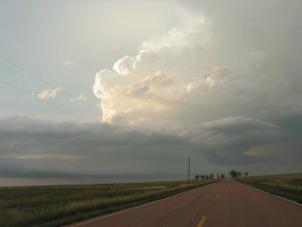
only slowly eastward, and towering cumulus were dotting the western horizon
by the time I reached
Faulkton. Not yet wanting to commit to either north or south, I watched
and waited on highway 212 west of town for a few moments.
 |
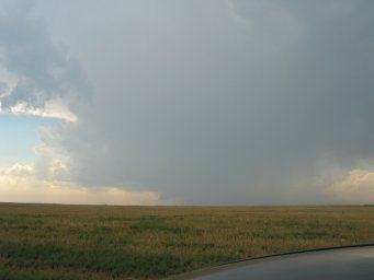
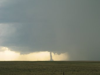
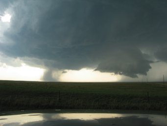
A pair
of cumulonimbus rose over eastern Dewey county around 2:45pm. The
southern updraft gradually began to thrive as it crossed Lake Oahe, shown in
this photo with its dissipating sidekick. Not yet observing any
development farther north, I dropped south out of Lebanon SD on gravel roads
to get into better position. (Paved roads were exceedingly scarce in
this area.) |
 |
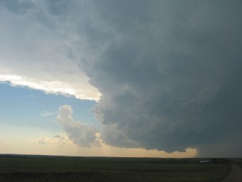
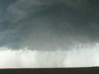
By
4:00pm, the compact storm had developed a healthy FF core and occasionally
displayed weakly rotating lowerings, as in this photograph. |
 |
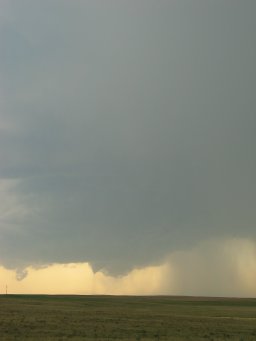
I
navigated around the Stone Lake Public Shooting Area (unfortunately I left
my rifle at home...), second-guessing my decisions as a storm nearer the
ND-SD border intensified and garnered a tor-warning. Then everything
changed, so to speak... as the storm's updraft strengthened rapidly and
began lowering its base (420pm), becoming a bonafide classic supercell!
A wall cloud with very impressive rotation developed soon after. |
 |
These
photos of course don't show it well, but mega-zooming with the camcorder
revealed that a great deal of dust was being generated near the ground
directly beneath the wall cloud. Review of video suggested this was
probably not tornadic in nature. |
 |
The
wall cloud took on an outflowish appearance thereafter as I was forced to
jog eastward for the next south option. Then my gravel road split
before I expected it would (a GPS would have been helpful). With the
storm moving swiftly my way at 35mph, I immediately re-traced my steps on MS
Streets & Trips to see where I'd goofed. |
 |
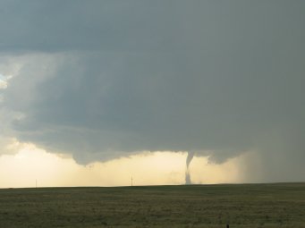
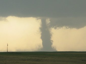
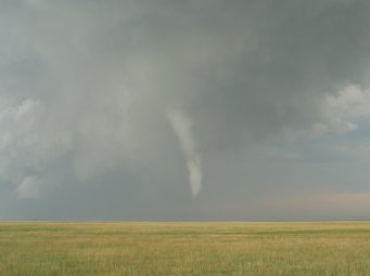
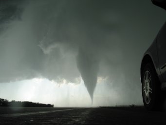
Then I
glanced up and noticed a tornado was on the ground already (436pm), in spite
of T/Td spreads ~22F that far west. I found a good viewing position
near what I was pretty sure was 327th Ave & 185th St (which ended up being
correct). This was in extreme northwestern Hyde county, looking
west-southwest toward central Sully county. |
 |
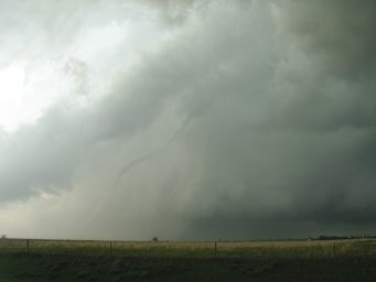
The
tornado was extremely high-based, and tracked 18 through 14 miles away from
me per ABR storm survey. |
 |
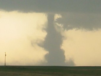
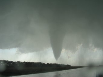
The
translucent tube gradually filled in with condensation & dust. Cloud
tags rotated cyclonically around, revealing the entire tornado. The camcorder viewfinder revealed that the rate of rotation in the funnel
was already respectable. |
 |
|
 |
|
 |
|
 |
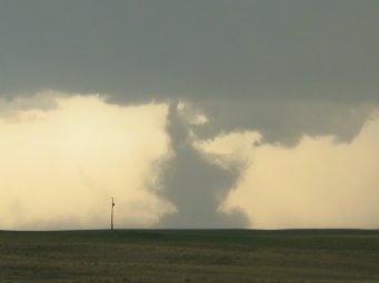
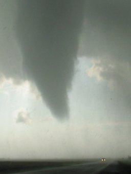
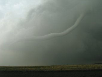
Tornado became more of a dirt-choked stovepipe and began to accelerate
southeastward. |
 |
Wrapping motions were quite dramatic by this point. |
 |
|
 |
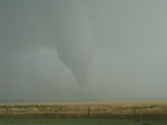
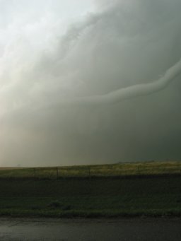
The
condensation funnel constricted and leaned over within outflow. |
 |
|
 |
Condensation dissolved (449pm), with weak
circulation hanging on a while longer within broader bowl of dirt.
Beautiful, RFD-scoured RFB above looked like a carbon copy of the
post-tornadic 06/07/05 storm in southwest SD. Cyclic formation of a new mesocyclone occurred over
the next 10 minutes as I drove south and phoned the NWS to refine the
location of the tornado. |
 |
Dissipating Onida tornado beneath old mesocyclone on the left; rapidly
condensing cloud material on the right, which is where the new mesocyclone
was born (456pm). |
 |
The beefy low-level meso took shape in 10-15 minutes, and was far
lower to the ground than the previous one. |
 |
The mesocyclone crossed the road
behind me at 327th Ave & 185th St. A
modest RFD blast followed. The feature at the center of this photo
then produced a vigorous dirt-churning tornado in the field immediately next
to the road from 510-512pm. Video only. |
 |
The
mesocylone became very wet and disorganized as I made the 7 mile jog
eastward to dry pavement (N-S Highway 47). Upon arriving, I observed
this snaky funnel extending 2/3 of the way to the ground (523pm). No
touchdown confirmed. |
 |
I drove
south a few miles to get some breathing room again. A quick look back
indicated the storm was clearly re-organizing and strengthening. |
 |
I
continued south. There was nary a gravel road to be found off of this
stretch of highway in Hyde county, and it appeared I'd have to go all the
way south to Highmore and then take Highway 14. Suddenly, a large
lowering appeared in my side rearview mirror. I turned around and drove back
north again, filming the rapid evolution of a gorgeous
truncated cone tornado ~2 miles to my northeast. It quickly narrowed
into a stovepipe, strongly resembling the taller tornado of the Stockton KS pair on 06/09/05. Finally, just
before I
pulled over and snapped this photo, the tornado began to dissipate in the most
interesting of ways: it broke into three pieces. Tornado time
5:33-5:36pm. |
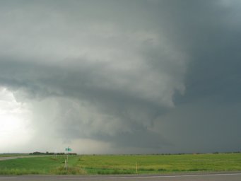 |
As I
headed east on Highway 14, the inflow-outflow interface of the storm became
quite remarkable. |
 |
As the
impressive, arcing RFD slot cut in, the storm was definitely getting "the
look." Feeling a tornado was imminent, I moved north for a closer
view. The area of interest was the agitated cone-shaped lowering above the
sunflower field. It didn't produce, and I headed back to the pavement. |
 |
The
inflow band became even more pronounced as I attempted to "beat" the storm
to the town of Miller. In a strangely humorous moment, I observed a
man casually exiting a roadside rest area (which consisted of a single
porta-potty type unit for him and for her). As he returned to his
vehicle, he glanced nonchalantly over his shoulder at the storm. A
tornado would touch down north of the porta-potties a minute later; I can
only assume he escaped the area unscathed. |
 |
I
turned back west and watched as the tornado was born (6:04pm) just north of
Highway 14. My hail-ravaged car roof provided a lovely mirror image of
the scene. |
 |
I was
acutely aware of the rainbands closing in on me from the north. |
 |
Condensation eased up for a moment as a car whizzed in front of the tornado. |
 |
The
first raindrops began to fall as condensation returned to ground level and
crossed Highway 14. |
 |
A
flurry of birds screamed southward to escape. |
 |
This
car drove right through the tornadic circulation. |
 |
Heavy
rain and pea-sized hail ensued. |
 |
The
tornado moved southeast into wheat stubble fields and became a drillpress
with a dynamic debris fan at ground level (much more apparent on video).
The tornado wrapped completely in rain at 6:11pm. |
 |
Headed
south from Miller on Highway 45 and saw a silver-white tornado thrust out
the back side of the ragged mesocyclone (possibly the same tornado as the
previous one), along with a vivid double rainbow. I observed this
tornado from 6:20pm until 6:22pm, when grabbing for my digital camera again
brought about its demise. I was well behind the storm by this point.
Highway 14 continued east and then southeast out of Miller, and would put me
back in the game fast... but at what expense? I had no option but to
use the side roads once again. |
 |
After
many minutes of sunny driving, I drove back beneath the shadow of the
supercell. Gradually I gained enough contrast to make out the
mesocyclone, which was entirely shrouded in precipitation. After
having stair-stepped 31 miles on gravel since Highway 45, I finally reached
pavement near the town of Virgil and headed dutifully east. The
ridiculous inflow band came back into view, shown here. |
 |
A snaky
rope tornado appeared suddenly off to my northwest (7:19pm). |
 |
The
tornado moved fairly quickly east-southeast, coming out into the sun and
growing thicker. |
 |
Stretching. |
 |
The
tail end became vertical and planted itself firmly on the ground. The
tornado took on a shape nearly identical to the Cheyenne WY rope-out years
ago. |
 |
In the
last minute, the tornado had lengthened by about a factor of two. |
 |
At this
point, a brown froth of heavy precip enveloped the tail of the tornado,
while the "top" half moved out over Highway 37 and developed some wild
kinks. Rotation within this funnel was impressive. |
 |
Same
shot, cropped to show the most wildly spinning portion. As the RFD
picked up, I instinctively switched to video (good call). The tail of
the tornado came into view once again. In the craziest scene I've ever
witnessed, the middle segment of the tornado bucked upward in response to
the strong outflow, while the tail--stark white within the dark brown
rainbands--pushed *rapidly* across the highway and into a grove of trees.
The best way I can describe the tail's behavior is to compare it to a
ballerina tip-toeing as fast as she can while trying desperately not to fall
down. (Sounds strange, I'm sure.) The tornado was literally
blown apart seconds later at 7:23pm. |
 |
I stuck
to highways for the remainder of the chase, which cost me the Cavour
tornado. I re-approached the supercell here from south of Carthage,
where laminar low-level structure indicated that increasing CINH north of
the warm front was beginning to take its toll on the storm (8:00 pm).
When I reached the updraft base near Carthage, it was very wet and very
non-descript. |
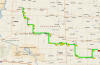
observed tornadoes

23Z modified RUC sounding at Miller SD
Sfc
T/Td: 86/72 F
MLCAPE:
3908 J/kg
MLCINH:
0 J/kg
0-3 km
MLCAPE: 127 J/kg
MLLCL:
1280 m
MLLFC:
1334 m
storm
motion: 300 deg @ 32 kts
0-1 km
SRH: 129 m2/s2
0-3 km
SRH: 311 m2/s2
additional
facts:
total
mileage while actively chasing: 202 miles
total time
while actively chasing: ~5 hours
total time
observing the supercell: ~4 hours
total time
observing tornadoes: 31 minutes
tornadoes
observed: 6 (F1, F0, F0, F2, F0, F0)
distance &
average speed of supercell between tornadoes 1 and 6: 91 miles @ 35mph


