Sunday, June 12, 2005
Another chase account written a few years after the fact. Had no sleep and a long drive to reach the target area, but made it to the
storm of the day (if a little late)... made a couple tactical errors which cost me good views of this very beastly west Texas supercell.
![]() |
Departed KC at about 430am and "intercepted" a severe MCS along the KS turnpike about 2 hours later. |
![]() |
|
![]() |
|
![]() |
|
![]() |
|
![]() |
After a data stop in Shamrock, headed down to the Turkey TX area in time to check out some developing storms along the dryline (340pm). |
![]() |
The storms were poorly organized and struggled for quite some time. |
![]() |
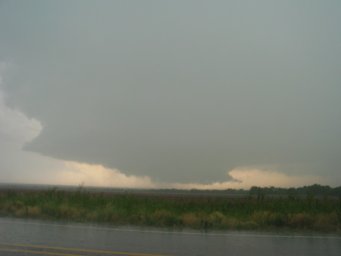
Dropped down on Highway 70 toward Matador as cells began increasing farther south along the dryline. Continued onward into northern Dickens county and intercepted a very beefy supercell and possible brief tornado (506pm) |
![]() |
510pm |
![]() |
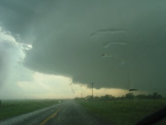
519pm - from the looks of this updraft, the low-level thermodynamic environment was incredibly sweet ahead of the dryline for this event |
![]() |
534pm - waffled back and forth between this storm and the developing tail-end charlie in Garza county. This LP storm was in between the two. |
![]() |
559pm - finally committed and made it down into northern Kent county to see the beast of an updraft |
![]() |
600pm |
![]() |
601pm |
![]() |
602pm - cloud base motions increasing |
![]() |
605pm - a large stovepipe tornado develops and persists for a couple minutes |
![]() |
|
![]() |
622pm - I underestimate the distance and movement of the storm and, unsure I can beat it across the highway, I head east and south |
![]() |
634pm - I come back out of the rain again north of Jayton to view an incredible "wedding-cake" HP |
![]() |
636pm |
![]() |
638pm - thought this was the general "interest area" due to massive amounts of rapidly condensing inflow |
![]() |
640pm |
![]() |
654pm - continue southward toward Jayton and a tornado "comes out of the rain" on the hind end of the updraft |
![]() |
|
![]() |
655pm |
![]() |
I abandon the storm and head south for an ongoing supercell, reaching it about an hour later in Fisher county TX (west of Hamlin). To say the storm was highly electrified would be an understatement. |
![]() |
754pm - obvious HP/outflowish characteristics |
![]() |
759pm |
![]() |
803pm |
![]() |
804pm |
![]() |
805pm |
![]() |
823pm |
![]() |
827pm - sun sets behind a line of chasers ~100 cars long |
![]() |
a nice sunset beneath the storm's backsheared anvil |
![]() |
|
![]() |
|
![]() |
Maps, weather data |
representative hodograph via Jayton profiler
storm motion: 290 deg @ 18 kts
0-1 km SRH: 230 m2/s2
0-3 km SRH: 454 m2/s2
0-1 km bulk shear: 25 kts
0-6 km bulk shear: 47 kts
7-10 km SR flow: 28 kts