May
29 2008 chase
I took a limited
number of digital stills during this stormchase, but until I can make
some video captures I will post this relatively brief account. Keeping in
tune
with other spring 2008
events I'd been able to chase, this was a somewhat challenging severe weather
forecast/chase day. Medium range models really struggled
with the setup in the days leading up to the event. By the morning of, a High Risk
was issued by SPC for eastern NE/northwestern IA, with a Moderate Risk
extending into
northwestern/northcentral KS. As a mid-level wind max translated through
parts of SD/NE/MN/IA, initiation would occur a bulging dryline
across the central high
plains. Upon departing I favored southcentral NE targets, where favorable
low-level thermodynamics (richest boundary layer moisture and
relatively cool capping
aloft) would seemingly be the "most backed up" to the dryline. I was somewhat concerned with
how convection would evolve,
as relatively widespread
initiation would occur by mid-afternoon... and with initially high LCLs and
low-level shear not increasing until ~23Z, I feared that
cold pooling and upscale
growth might result in outflow-dominant and/or clustered supercells. I
reached Kearney around 17Z, and my thoughts changed little
after analyzing new data.
A number of storms initiated over southwestern NE/northwestern KS by 1930Z.
Though cloud bases would likely remain too high
for an appreciable tornado
threat until one reached
longitudes nearer Kearney, I was still afraid of an "early show" and rushed west
to intercept.
 |
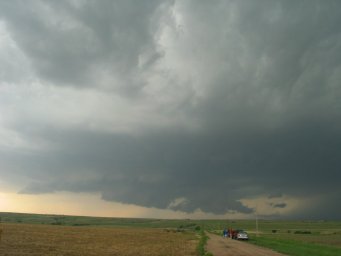
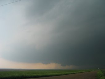
Tornado-warned supercell moving
swiftly between McCook and Lexington NE... viewed here at ~400pm CDT looking WSW from a point 4
miles south of Elwood. I had arrived at this location about 20
minutes prior, but initial views were quite hazy and low-contrast
|
 |
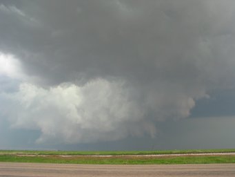
The storm would
occasionally display rather chunky wall clouds, but they'd then take on an
outflow-ish appearance as shown here. |
 |
|
 |
I moved back north and headed east
out of Elwood as a large, broiling, forward flank gust front appeared to form.
|
 |
As the storm moved into Phelps
county around 440pm, supercellular characteristics became pronounced once again.
A beautiful, classical-looking mesocyclonic structure evolved, with a clear slot
revealing vigorous convection quite low to the ground. I was a bit lazy and
stayed on the main highways curving ESE while the storm scooted ENE away from me.
|
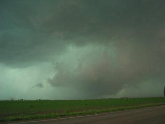 |
I caught back
up with the storm around 520pm near Kearney. I could see a
well-defined, occluding meso to my north, which strongly looked like an
"active" tornadocyclone. I noted a powerflash or two amidst occasional
cloud-to-cloud lightning strokes (a rain-wrapped tornado causing isolated
EF-2 damage, as surveyed by NWSGID). By the time I pulled close to the
area of interest, I came upon an increasingly ill-defined low-level meso as
in photo. |
 |
I chased the
storm ENE along Highway 30 as strong HP characteristics became apparent
(~600pm, as in photo). The storm crossed the highway near Shelton,
cutting my route off. I dropped back south to I-80 and continued
east... but near Grand Island made the decision to abandon the storm and
drop south to the cells in far northern Kansas. As gorgeous as the
00Z
Omaha RAOB was, I suppose I am partially lucky the storm I abandoned didn't
get its act back together and become a tornado machine; if not for the way
the convection ended up evolving (early transition to HP-mode), the most
prolific/visible
tornado outbreak seemingly should have been over southcentral/eastern
NE on this day. |
 |
I made my way
south on Highway 281 and then Highway 78... targeting two persistent,
tornado-warned cells moving ENE from the Stockton/Plainville KS areas.
I considered stopping for gas just north of the state line at a lone
convenience store in the town of Guide Rock... but pressed on, naturally
fearing "being late" and hoping I could get by on what I had left. I
crossed into Kansas and encountered the first target storm near
Ionia... and immediately bypassed it given its weak and high-based
presentation. Unfortunately, by this point it was becoming clear that
continuing on without gassing up would be a gamble... and I was forced to
rush east to Beloit and grab a few gallons. After doing so, I headed south and then west on
Tipton Road and encountered target storm #2--an incredibly beastly supercell--at
~820pm, as in photo. |
 |
Conditions were very hazy and
my video and photo stills did not turn out particularly well, at least
initially. The storm was quite laminar in the lowest couple kilometers
(a manifestation of weak to nil low-level bouyancy and increasing CINH)...
which served to further enhance the unbelievable "mothership" structure. |
 |
I headed a bit
farther west and stopped at a point 7SW of Glen Elder or 7SE of Cawker City.
The low-level structure was extremely "beefy" (somewhat comparable to the
Kent county storm of 06/12/2005), replete with an ominous wall cloud... and
it was tough to imagine tornadogenesis not occurring soon. Strong east
or even northeast inflow winds were blasting into the updraft, and were
unbelieveably warm and moist such that it literally felt like a steam bath.
(METARs revealed it was likely 80/68, which in hindsight is not terribly
impressive I suppose). By this point, my day had already been "made"
given the incredible supercellular structure... possibly the best I have
ever witnessed. |
 |
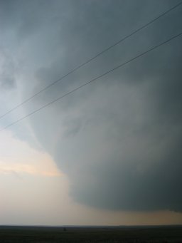
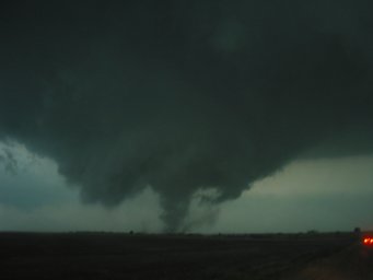
A truncated
stovepipe tornado was born at 831pm in advance of the wall cloud, and
persisted for about a minute and a half. The wall cloud then began
rotating violently and evolved into a multiple vortex tornado at 833pm.
Meanwhile, intense cascading rotation on the forward lip of the meso just to
the right/north of Tipton Road (not pictured) produced a second simultaneous
tornado at ~834pm. The wall
cloud began to break apart as the tornado continued as a dust bowl (as in
photo). The tornado weakened around 836pm, crossing the road to my
immediate west in the form of slowly/broadly rotating rain curtains. |
 |
I repositioned east a couple
miles. The "Glen Elder to
Jewell tornado" more or less initiated at this time (840pm), with occasional multiple vortices
condensing beneath an increasingly
beefy low-level mesocyclone. Note one of the vortices in the
photo. A couple of these were quite thick in the form of beautiful
"ropes." |
 |
Larger vortices
began forming and revolving around one another. Some wrap-around
rain began to fall at my location. I think I inadvertently had the
flash on for this photo. |
 |
Tornado took on
a truncated cone shape as it passed over Waconda Lake and toward the town of
Glen Elder... with a gorgeous "midnight blue" color to the clouds.
What a sight this must have been at ground level had one been positioned
right near the lake. |
 |
I drove north
on Glen Elder Dam Road, noticing (EF-2 rated) damage to some farm buildings.
I encountered widespread tree damage in the town of Glen Elder, with many of
the city streets completely blocked by fallen trees. (Luckily, it
seems as though the tornadic circulation stayed primarily south/east of
town). Highway 24 was blocked off by a couple of downed powerpoles...
ending the chase. I could still see the tornado continuing to my
northeast, though it was a bit non-descript... looking high-based and
partially rain-wrapped in the twilight. Oddly enough, the supercell
produced a second even longer-track tornado along the Courtland
KS-Belleville KS-Fairbury NE corridor, with very
strong SRH apparently compensating for lacking low-level CAPE and
considerable CINH. |
observed supercells
observed tornadoes (paths
estimated)
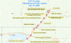
NWSGID storm survey

21Z
subjective surface analysis

03Z modified RUC sounding at Belleville KS (representative of second long-track
tornado)
Sfc
T/Td: 75/69 F
MLCAPE:
2765 J/kg
MLCINH:
122 J/kg
0-3 km
MLCAPE: 0 J/kg
MLLCL:
936 m
MLLFC:
2934 m

03z modified RUC
hodograph at
Belleville KS, with 02Z Haviland profiler substitued in 2-3.5 km layer
storm
motion: 232 deg @ 34 kts
0-1 km
SRH: 661 m2/s2
0-3 km
SRH: 742 m2/s2
0-1 km bulk shear: 55 kts
0-6 km bulk shear: 61 kts
7-10 km SR flow: 34 kts


